One of the oldest applications of 3D city models is the study of solar potential (also called solar atlas, or even solar cadastre), precisely calculating the incident solar energy on each slope of roof and façade of the buildings and urban infrastructure.
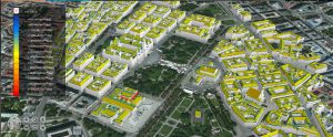
Solar atlas in the center of Vienna – source: project iScope
From a certain threshold of solar annual received, a roof or façade can provide cost-effective support for the installation of thermal solar panels or photovoltaic. The identification of these surfaces and the estimation of renewable energy that can be produced there is an essential step of a climate Plan energy territory. Many cities have put this information online via a web – GIS (usually 2D, sometimes 3D).
The algorithms are based on models of sky (Perez, Hai etc.) and solar radiation (radiosity, ray tracing, etc.). They usually take into account interactions with the adjacent buildings (shadow and reflection), reliefs and the surrounding vegetation.
Prerequisites: city 3D model LoD2 (at least), model of distant land in the event of important reliefs. Possibly information of vegetation.
Initiatives & contacts
Project iScope
- Coordinator: Raffaele Amicis, Fondazione Grapitech
- Beauty (English link requires a recent version of java)
Berlin Solar Atlas / Energy Atlas Berlin
- Main partners: YOU Berlin, town of Berlin, VirtualCitySystems
- Beauty (English link)
- Contact: Till Belusa