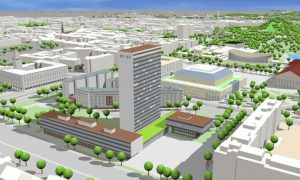
3D city models provide a realistic city visualization as it is currently, or as it could be due to a new urban development project. They skillfully juggle overviews and zooms immersing the user in the streets, rooftops, embedded in this virtual city such a video game in the first person.
CityGML visualization – source: ArcGIS blog
Thanks to the different levels of Detail, it is possible to visualize the different steps of the new urban project, the ground plane (LoD1) detailed design (LoD4). The cadastre can be precisely managed, 2D or even 3D in the case of building overlapping infrastructures or other buildings. Thus a space envelope, such a giant virtual container, can be set before each build, delimiting the grip to the ground, the height and shape of the building to be built. Based on simulations of shadow and sunshine, this envelope can also have the aim to control the impact of a new building or block on the adjacent buildings in terms of access to the Sun. The same concept can be developed with studies of visibility (view on the sea, on a historical monument etc.).
Working on the same digital urban model, communication between the developer, the lessor and the architect is fast and seamless. Similarly, those affected by the new urban development project can involved in the process of reflection and acceptance, having in front a very realistic impression of what awaits them.

